Examples
The agent chooses which tools to call and with what. Each example shows a real call and the result it returned.
Recolor a style and check the change
Section titled “Recolor a style and check the change”This is the Claude Code session that the home page walks through. The prompt was:
style.json is a copy of OpenFreeMap's Liberty style, https://tiles.openfreemap.org/styles/liberty. Make the motorways red in style.json. Then check that the style is still valid, and show me a before and after around Copenhagen.
The agent searched style.json for the motorway layers, read their paint properties, and ran validate_style on the file before changing it. It then made three edits to the colors, ran validate_style again, and compared the original style with the file:
{ "before": {"url": "https://tiles.openfreemap.org/styles/liberty"}, "after": {"path": "style.json"}, "center": [12.5, 55.68], "zoom": 10, "width": 600, "height": 450}compare_styles returned this image and text:
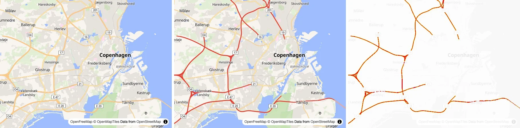
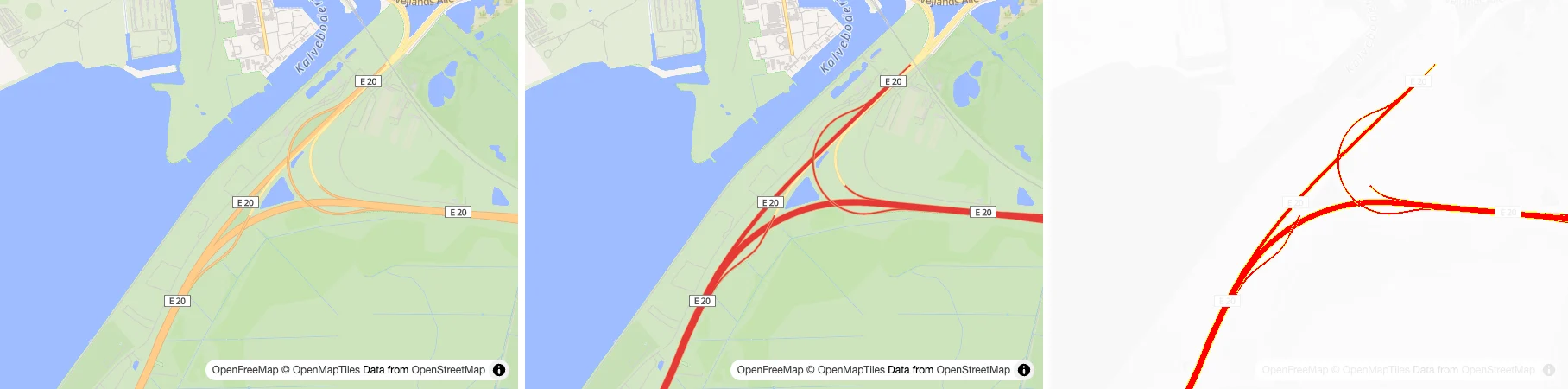
Left to right: Before, After, and the differences in red.1.48% of the pixels differ (3986 of 270000).Camera: center [12.5, 55.68], zoom 10, bearing 0, pitch 0.Before: Rendered with MapLibre GL JS 6.11.2.After: Rendered with MapLibre GL JS 6.11.2.It checked again closer in, at zoom 13 over the E20 interchange on Amager:
Then it answered:
Motorways in style.json are now red, the style still validates cleanly, and the before/after comparisons around Copenhagen show only the motorways changing.
Catch layers that don't match the data
Section titled “Catch layers that don't match the data”A layer that uses a source layer or field the tiles don't have draws nothing, and the map raises no error. This style has two such layers. OpenMapTiles calls the source layer building, not buildings, and has no kind field in transportation:
{ "id": "buildings", "type": "fill", "source": "openmaptiles", "source-layer": "buildings", "paint": {"fill-color": "#d6d0c4"}},{ "id": "motorways", "type": "line", "source": "openmaptiles", "source-layer": "transportation", "filter": ["==", ["get", "kind"], "highway"], "paint": {"line-color": "#e53935", "line-width": 3}}describe_sources reads the TileJSON of each source and checks every layer against it:
Sources:openmaptiles (vector), used by 3 layers  TileJSON: https://tiles.openfreemap.org/planet  Zoom 0 to 14.  Source layers and their fields:    aerodrome_label: class, ele, ele_ft, iata, icao, name, name:* (79 fields), name_de, name_en, name_int    aeroway: class, ref    boundary: adm0_l, adm0_r, admin_level, claimed_by, class, disputed, disputed_name, maritime, name, name:* (68 fields), name_de, name_en, name_int    building: colour, hide_3d, render_height, render_min_height    housenumber: housenumber    landcover: class, subclass    landuse: class    mountain_peak: class, customary_ft, ele, ele_ft, name, name:* (80 fields), name_de, name_en, name_int, rank    park: class, name, name:* (80 fields), name_de, name_en, name_int, rank    place: capital, class, iso_a2, name, name:* (80 fields), name_de, name_en, name_int, rank    poi: agg_stop, class, indoor, layer, level, name, name:* (80 fields), name_de, name_en, name_int, rank, subclass    transportation: access, bicycle, brunnel, class, expressway, foot, horse, indoor, layer, level, mtb_scale, network, official, oneway, ramp, service, subclass, surface, toll    transportation_name: class, indoor, layer, level, name, name:* (80 fields), name_de, name_en, name_int, network, ref, ref_length, route_*_colour (16 fields), route_*_name (21 fields), route_*_network (21 fields), route_*_ref (18 fields), subclass    water: brunnel, class, id, intermittent    water_name: class, intermittent, name, name:* (80 fields), name_de, name_en, name_int    waterway: brunnel, class, intermittent, name, name:* (80 fields), name_de, name_en, name_int
Problems:  Layer "buildings" uses the source layer "buildings", which "openmaptiles" does not have. It has: aerodrome_label, aeroway, boundary, building, housenumber, landcover, landuse, mountain_peak, park, place, poi, transportation, transportation_name, water, water_name, waterway.  Layer "motorways" reads the field "kind", which "openmaptiles" does not list for "transportation".
To fix the filter, the agent needs to know what the roads are called. inspect_tile reads the tile over Copenhagen at zoom 10 and counts the values of each field:
Tile 10/547/320 of https://tiles.openfreemap.org/planet, at [12.57, 55.68], MVT, 102.5 kB.
transportation: 67 features (67 LineString)  subclass (in 5 of 67): "rail" (5)  brunnel (in 8 of 67): "tunnel" (6), "bridge" (2)  class: "primary" (28), "secondary" (19), "motorway" (10), "rail" (5), "trunk_construction" (2), "trunk" (2), "ferry" (1)  ramp (in 21 of 67): 1 (21)
So the filter becomes ["==", ["get", "class"], "motorway"].
debug_layers answers the same question from the other end, for a place. It reads the tiles there and says for each layer whether it draws, and if not, why:
At [12.57, 55.68], zoom 14: 2 draw nothing.Read source "openmaptiles": tile 14/8764/5127, MVT.
buildings (fill): draws nothing, since the tile has no source layer "buildings". It has: boundary, building, housenumber, landcover, landuse, park, place, poi, transportation, transportation_name, water, water_name, waterway.motorways (line): draws nothing, since its filter matches none of the 568 features in source layer "transportation". No feature has the field "kind".
It also asks the glyph server for the fonts of each label layer. GL JS draws text in a font the server lacks with local fonts, and MapLibre Native leaves it out:
places (symbol): draws 16 of the 16 features in source layer "place". Its text is drawn with local fonts, since the glyph server lacks the font stack "Open Sans Bold".Look up the style specification
Section titled “Look up the style specification”Mapbox GL JS has properties that MapLibre doesn't, and models mix the two up. describe_style_spec answers from the MapLibre Style Specification, so it catches a property from Mapbox's lighting, and suggests the closest names for a typo:
"line-emissive-strength" is not in the MapLibre Style Specification."fill-colour" is not in the MapLibre Style Specification. Did you mean: fill-color?For a name it knows, it returns the documentation, and the versions of GL JS and MapLibre Native that support each part:
fill-extrusion-height (paint property of fill-extrusion layers)The height with which to extrude this layer. Negative values extrude below ground level, so a floor that is entirely underground can be expressed.Type: number. Default: 0. Units: meters. Transitionable.Expressions can use zoom, feature, feature-state, and the value can be interpolated.Support: basic functionality: GL JS 0.27.0, Android 5.1.0, iOS 3.6.0 data-driven styling: GL JS 0.27.0, Android 5.1.0, iOS 3.6.0 [`global-state`](https://maplibre.org/maplibre-style-spec/expressions/#global-state) expression: GL JS 5.6.0, Android not yet (https://github.com/maplibre/maplibre-native/issues/3302), iOS not yet (https://github.com/maplibre/maplibre-native/issues/3302) negative values: GL JS not yet (https://github.com/maplibre/maplibre-gl-js/issues/8051), Android not yet (https://github.com/maplibre/maplibre-native/issues/4455), iOS not yet (https://github.com/maplibre/maplibre-native/issues/4455)Look up the GL JS API
Section titled “Look up the GL JS API”Models write GL JS code from memory, which mixes in Mapbox GL JS methods and older versions. describe_gl_js_api answers from the type definitions of the GL JS version the server renders with, so it says when a method isn't there:
Map has no member "setFog" in MapLibre GL JS 6.11.2.For a name it knows, it returns the signature, documentation, default and examples, with a link to the docs page:
MapOptions.maxPitch (property of MapOptions, MapLibre GL JS 6.11.2)maxPitch?: number | nullThe maximum pitch of the map (0-180).Default: 60Docs: https://maplibre.org/maplibre-gl-js/docs/API/type-aliases/MapOptions/#maxpitchFor a class or an options type, it lists the members. With version, it answers for another GL JS version instead, like the "5" a project uses.
Compare GL JS and MapLibre Native
Section titled “Compare GL JS and MapLibre Native”With the gl-js and native toolsets on, compare_renderers draws one style with both, to check that it looks the same on the web and in the mobile SDKs:
{ "url": "https://tiles.openfreemap.org/styles/liberty", "center": [12.5862, 55.6798], "zoom": 15.2, "bearing": -25, "pitch": 55, "width": 420, "height": 300}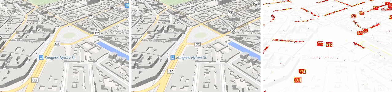
Left to right: gl-js, native, and the differences in red.3.07% of the pixels differ (3866 of 126000).Camera: center [12.5862, 55.6798], zoom 15.2, bearing -25, pitch 55.gl-js: Rendered with MapLibre GL JS 6.11.2.native: Rendered with MapLibre Native 6.5.0-pre.1.The two agree, apart from where a few labels land.
Show the user a map
Section titled “Show the user a map”show_map puts an interactive map in the chat, in clients that support MCP Apps. The live map on the home page draws what this call shows, a walk from Nyhavn to Tivoli:
{ "layers": [ { "type": "fill", "data": {"type": "Polygon", "coordinates": [[[12.566, 55.6746], [12.5705, 55.6744], [12.5712, 55.6727], [12.5669, 55.6718], [12.5655, 55.673], [12.566, 55.6746]]]}, "paint": {"fill-color": "#e53935", "fill-opacity": 0.25} }, { "type": "line", "data": {"type": "LineString", "coordinates": [[12.5903, 55.6798], [12.5856, 55.6797], [12.5822, 55.6786], [12.5776, 55.678], [12.5747, 55.677], [12.5708, 55.6761], [12.5694, 55.6757], [12.5683, 55.6746]]}, "paint": {"line-color": "#295daa", "line-width": 5}, "layout": {"line-cap": "round", "line-join": "round"} } ], "markers": [ {"position": [12.5903, 55.6798], "label": "Nyhavn", "color": "#295daa"}, {"position": [12.5683, 55.6746], "label": "Tivoli", "color": "#e53935"} ]}The agent gets a short confirmation back, since only the user sees the map:
Showing the user a map with 2 layers and 2 markers.Pick libraries and map data for an app
Section titled “Pick libraries and map data for an app”With the ecosystem toolset, the agent answers "what should I use?" from Make with MapLibre. In this Claude Code session, only its two tools were available. The prompt was:
I'm building a hiking web app in React. I want a MapLibre map with a free basemap and 3D terrain, and users should be able to draw a planned route on it. Which libraries and map data should I use, and how do I set them up?
The agent searched for each part of the question, with these calls to search_ecosystem:
{"query": "react", "platform": "Web"}{"query": "draw", "kind": "plugin"}{"kind": "routing"}And these to find_basemaps:
{"free": true}{"query": "terrain"}{"query": "elevation"}The search for drawing plugins returned eight, the first two here:
8 entries match "draw", kind plugin:
maplibre-gl-terradraw (plugin, drawing): Drawing and measuring toolbar on Terra Draw  A MapLibre GL JS control that puts Terra Draw behind a ready-made toolbar: points, lines, polygons, circles, freehand and text, with select, undo, GeoJSON download, and a measuring variant.  Web · JavaScript, TypeScript · MapLibre GL JS · MIT  https://github.com/watergis/maplibre-gl-terradraw, docs https://terradraw.water-gis.com/, npm https://www.npmjs.com/package/@watergis/maplibre-gl-terradraw  Live demo: https://makewithmaplibre.com/plugins/maplibre-gl-terradraw/#live-demo  More: https://makewithmaplibre.com/plugins/maplibre-gl-terradraw/
Terra Draw (plugin, drawing): Multi-library drawing tool  A cross-library drawing tool that works with MapLibre GL JS, Leaflet, OpenLayers, and Google Maps. Draw and edit geometries with a consistent API.  Web · JavaScript, TypeScript · MapLibre GL JS · MIT  https://github.com/JamesLMilner/terra-draw, docs https://terradraw.io, npm https://www.npmjs.com/package/terra-draw  Live demo: https://makewithmaplibre.com/plugins/terra-draw/#live-demo  More: https://makewithmaplibre.com/plugins/terra-draw/
The search for terrain found elevation tiles, with how to add them and the credit they need:
Terrarium Elevation by AWS Open Data, free, no API key: Global elevation tiles in Terrarium format. Use for hillshading and 3D terrain in MapLibre.  Tiles, to add as a raster-dem source with tileSize 256: https://s3.amazonaws.com/elevation-tiles-prod/terrarium/{z}/{x}/{y}.png  Elevation encoding: terrarium  More: https://makewithmaplibre.com/basemaps/styles/aws-terrarium/
Mapterhorn Terrain by Mapterhorn, free, no API key: Open elevation tiles in Terrarium format: 30 m worldwide and 1 m or finer where countries publish lidar data. Free with no API key; credit Mapterhorn and its sources. Use for hillshading and 3D terrain in MapLibre.  Tiles, to add as a raster-dem source with tileSize 512: https://tiles.mapterhorn.com/{z}/{x}/{y}.webp  Elevation encoding: terrarium  Attribution the map has to show: <a href="https://mapterhorn.com/attribution">© Mapterhorn</a>  More: https://makewithmaplibre.com/basemaps/styles/mapterhorn/
It recommended this stack, with setup code for each part:
| Need | Pick | Why |
|---|---|---|
| Map renderer | maplibre-gl |
The core library |
| React binding | React Map GL (react-map-gl/maplibre) |
Most widely used declarative wrapper, MIT |
| Basemap | Maptoolkit Hiking | Free, no API key, trails brought forward, hillshading and contour lines |
| Elevation | Mapterhorn Terrain | Free, no API key, 30 m worldwide and 1 m or finer where lidar exists |
| Drawing | maplibre-gl-terradraw | Ready-made toolbar on Terra Draw, with select, undo, and GeoJSON download |
It passed on what the providers require: Maptoolkit's logo control, and Mapterhorn's attribution, with tileSize 512 and the terrarium encoding in the raster-dem source. For drawing routes that follow trails, it pointed to Valhalla, GraphHopper and openrouteservice from the routing search. It ended with the credit the tools ask for:
Sources: Make with MapLibre by Birk Skyum, CC BY 4.0.